History & Geology
The Tectonic & Historic Advantage
We are targeting the right rocks at the right time. A world-class orogenic belt unlocked after a century of silence.
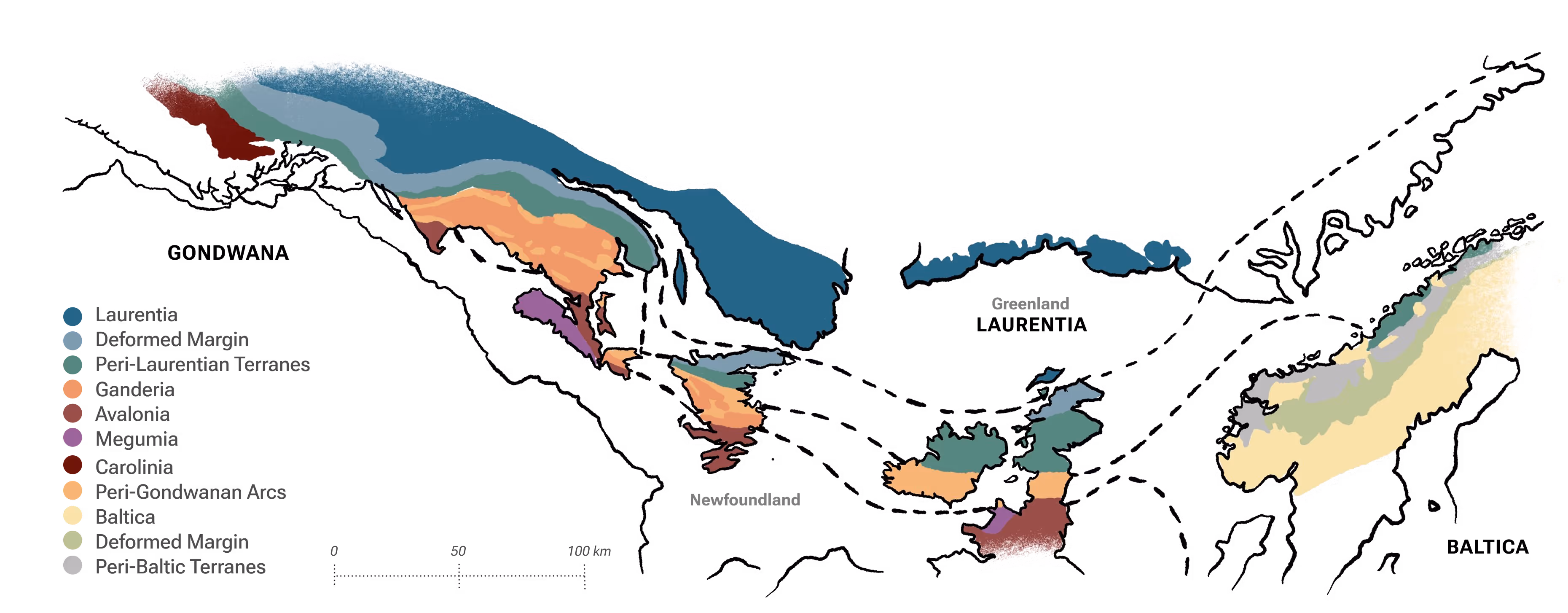

The Transatlantic Connection
Geology doesn't stop at the ocean. Before the Atlantic opened, Newfoundland was the "missing link" connecting Ireland and the Carolinas.
We sit at the heart of the Appalachian-Caledonian Belt. The rocks here are the crushed remnants of the ancient collision between the continents of Laurentia and Gondwana. This is the same tectonic belt that hosts the Dalradian gold belt in Northern Ireland (Curraghinalt). When the continents split, we inherited the western half of this massive gold system.
But simply being in the belt isn't enough. You need the right mechanism to bring the gold to the surface.
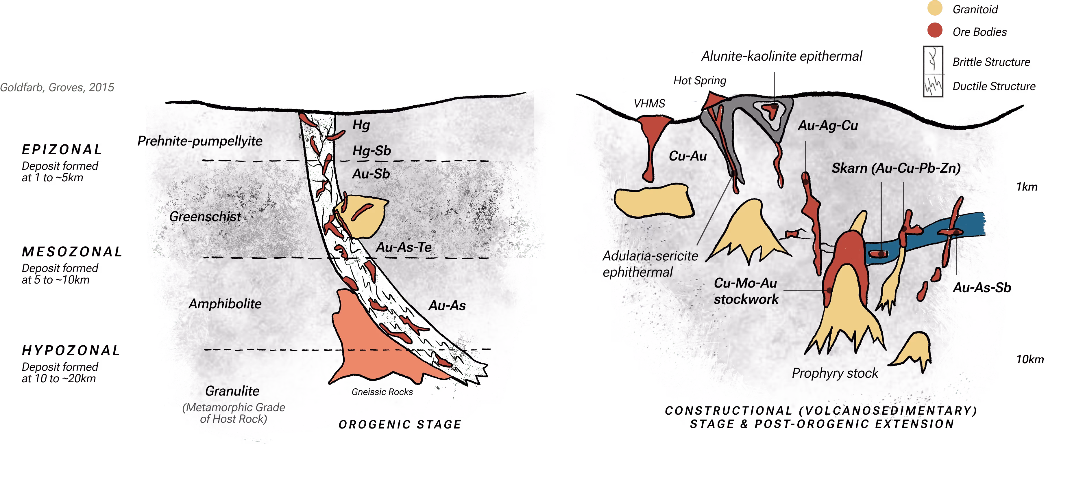
The Deep Crustal Pump
Geology doesn't stop at the ocean. Before the Atlantic opened, Newfoundland was the "missing link" connecting Ireland and the Carolinas.
We sit at the heart of the Appalachian-Caledonian Belt. The rocks here are the crushed remnants of the ancient collision between the continents of Laurentia and Gondwana. This is the same tectonic belt that hosts the Dalradian gold belt in Northern Ireland (Curraghinalt). When the continents split, we inherited the western half of this massive gold system.
We know the mechanism works globally. Now, let's look at where it happened locally.

The Tectonic Pressure Cooker
Gold on the island is not random; it is structural. Newfoundland is divided into three
distinct zones, but the gold is concentrated in the middle: The Dunnage Zone.

The Collision
The Trap
The Preservation
If the geology is so perfect, why wasn't this mined 50 years ago? The answer lies in history.

The Time Capsule Advantage
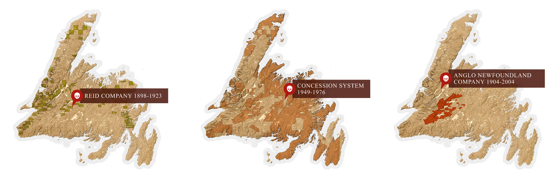
Why is a massive gold belt in a safe jurisdiction virtually untouched? It wasn't a failure of geology; it was a failure of history.
1. The Legal Lock-Up (1898–1976): While the Abitibi Belt in Ontario was booming under the 1906 Mining Act, Newfoundland was operating under an archaic colonial system that banned the average prospector from the best ground.
- The Reid Lots (1898–1923): Huge land grants were given to the Reid Newfoundland Company to build a railway. These lands were held by railroaders, not miners.
- The Anglo Concessions (1904–2004): For a full century, a massive block of the central gold belt was tied up in concessions to the Anglo-Newfoundland Development Company. Exploration was stagnant.
- The Result: Ordinary prospectors—the "boots on the ground" who historically find the big deposits—were legally locked out until the 1976 Minerals Act finally opened the island to staking.
2. The Glacial Veil: Even where the land was open, the rocks were hidden.
- The Problem: 77% of the island is covered by a thin blanket of glacial till (dirt and gravel left by ice ages). The old-timers simply couldn't see the gold-bearing outcrops.
- The Solution: We are the first generation to use modern airborne geophysics to "see through" this till cover, identifying the magnetic signatures of the fault structures below.